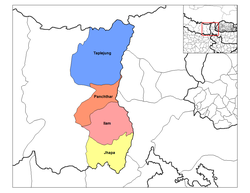
| Panchthar District | |
|---|---|
| — District — | |
| Country | |
| Region | Eastern (Purwanchal) |
| Zone | Mechi |
| Area | |
| - Total | 1,241 km2 (479.2 sq mi) |
| Population (2001) | |
| - Total | 202,056 |
| - Density | 162.8/km2 (421.7/sq mi) |
| Time zone | NPT (UTC+5:45) |
Panchthar District, a part of Mechi Zone, is one of the seventy-five districts of Nepal, a landlocked country of South Asia. The district, with Panchthar as its district headquarters, covers an area of 1,241 km² and has a population (2001) of 202,056. Panchthar's majority population is that of Kirantis (Limbu, Rais) and other ethnic groups and hill castes.
Village Development Committees (VDCs)
- Aangna
- Aangsarang
- Aarubote
- Ambarpur
- Bharapa
- Chilingdin
- Chokmagu
- Chyangthapu
- Durdimba
- Ekteen
- Embung
- Falaicha
- Hangum
- Khandrung* Ilam
- Khunga not in yet
- Kurumba
- Lalikharka* not in yet
- Limba
- Lungrupa
- Luwamfu*
- Mangjabung
- Mauwa
- Memeng
- Nagi
- Nangeen
- Nawamidanda
- Olane
- Oyam
- Panchami
- Prangbung
- Pauwa Sartap
- Phaktep
- Phidim
- Prangbung*
- Rabi
- Rani Gaun
- Ranitar
- Salleri*not in yet
- Sarangdanda
- Sidin
- Siwa
- Subhang
- Syangrumba*Ilam
- Tharpu
- Yangnam
- Yasok


No comments:
Post a Comment